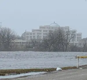
 The Red River in Grand Forks / East Grand Forks is expected to crest this week. The river jumped its banks of 28 feet Saturday morning and has been on a steady climb ever since.
Greg Gust of the National Weather Service in Grand Forks says the water won’t disappear overnight – but it won’t be a prolonged event either. The one wildcard is the potential for more precipitation at the end of the week.
The main high impact flooding will be primarily north of Fargo with major flooding expected from Grand Forks downstream.
● MN Tributaries: Crookston has crested above major flood stage. Tributaries seeing at least moderate impacts include the Roseau, Snake, and Red Lake Rivers.
● ND Tributaries: Moderate to major flooding is anticipated along the North Dakota tributaries including the Sheyenne, Goose, and Pembina Rivers. Crest is anticipated to be early this week.
The East Grand Forks council held a special meeting Monday night to extend the Flood Emergency until river levels drop back below the 28 foot flood stage. Both the Point and Sorlie bridges remain closed until further notice due flooding.
North Dakota Governor Doug Burgum today declared a statewide emergency for flooding and widespread utility infrastructure damage caused by a severe winter storm last weekend.
In eastern North Dakota, heavy rains and snowmelt swelled creeks and rivers within the Sheyenne and Red River basins and swamped fields and ditches. The statewide emergency declaration direct states agencies to provide response resources and capabilities and makes North Dakota National Guard resources available if needed to support local and tribal governments.
The National Weather Service in Grand Forks still has Flood Warnings and Advisories posted for all or portions of 23 North Dakota and Minnesota counties.


FOLLOW US FOR INSTANT UPDATES!


